Ovo je datoteka sa Vikimedijine ostave

Датотека:Earth Western Hemisphere.jpg

Iz Vojne Enciklopedije
Пређи на навигацију Пређи на претрагу

Оригинална датотека(2.048 × 2.048 пиксела, величина датотеке: 579 kB, MIME тип: image/jpeg)

Lua error: Cannot create process: proc_open(/dev/null): failed to open stream: Operation not permitted

Опис

Опис
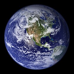
English: “Blue Marble”. Original caption:
Much of the information contained in this image came from a single remote-sensing device-NASA’s Moderate Resolution Imaging Spectroradiometer, or MODIS. Flying over 700 km above the Earth onboard the Terra satellite, MODIS provides an integrated tool for observing a variety of terrestrial, oceanic, and atmospheric features of the Earth. The land and coastal ocean portions of these images are based on surface observations collected from June through September 2001 and combined, or composited, every eight days to compensate for clouds that might block the sensor’s view of the surface on any single day. Two different types of ocean data were used in these images: shallow water true color data, and global ocean color (or chlorophyll) data. Topographic shading is based on the GTOPO 30 elevation dataset compiled by the U.S. Geological Survey’s EROS Data Center. MODIS observations of polar sea ice were combined with observations of Antarctica made by the National Oceanic and Atmospheric Administration’s AVHRR sensor—the Advanced Very High Resolution Radiometer. The cloud image is a composite of two days of imagery collected in visible light wavelengths and a third day of thermal infra-red imagery over the poles. Global city lights, derived from 9 months of observations from the Defense Meteorological Satellite Program, are superimposed on a darkened land surface map.
Датум
Извор http://visibleearth.nasa.gov/view.php?id=57723
Аутор
  • Reto Stöckli (land surface, shallow water, clouds)
  • Robert Simmon (enhancements: ocean color, compositing, 3D globes, animation)
  • Data and technical support: MODIS Land Group; MODIS Science Data Support Team; MODIS Atmosphere Group; MODIS Ocean Group
  • Additional data: USGS EROS Data Center (topography); USGS Terrestrial Remote Sensing Flagstaff Field Center (Antarctica); Defense Meteorological Satellite Program (city lights).
Остале верзије Derivative works of this file:  Environment Barnstar new.png

Лиценцирање

Public domain Ова датотека је у јавном власништву зато што је њен аутор НАСА. НАСА-а политика ауторских права наводи „Материјали НАСА-е нису заштићени ауторским правима осим ако није другачије наведено“. (Погледајте Template:PD-USGov, NASA copyright policy page или JPL Image Use Policy.)
Упозорења:
  • Употреба НАСА-их логотипа и емблема је ограничена Америчким законом 14 CFR 1221.
  • НАСА-ин сајт хостује велики број слика Совјетске/Руске свемирске агенције и других не-Америчких свемирских агенција. Ове слике нису нужно у јавном власништву.
  • Материјали засновани на подацима Хабл телескопа су слободни само ако је њихов аутор STScI.[1] Такође погледајте {{PD-Hubble}} и {{Cc-Hubble}}.
  • Материјали са сонде SOHO су заштићени ауторским правима и потребна је дозвола за комерцијалну употребу. [2]
  • Слике са сајта APOD можда подлежу ауторским правима. [3]

Поднаписи

Укратко шта ова датотека представља/приказује

Ставке приказане у овој датотеци

приказује

8. фебруар 2002

2.048 пиксел

2.048 пиксел

84cdf93465ae8f57874f2f03e1d574dec4261045

Историја датотеке

Кликните на датум/време да бисте видели тадашњу верзију датотеке.

Датум/времеMinijaturaДимензијеКорисникКоментар
тренутна03:09, 25. август 2005.Umanjeni prikaz za izdanje od 03:09, 25. август 2005.2.048 × 2.048 (579 kB)wikimediacommons>Tom{{PD-USGov-NASA}} http://earthobservatory.nasa.gov/Newsroom/BlueMarble/Images/globe_west_2048.jpg Much of the information contained in this image came from a single remote-sensing device-NASA’s Moderate Resolution Imaging Spectroradiometer, or MODIS.